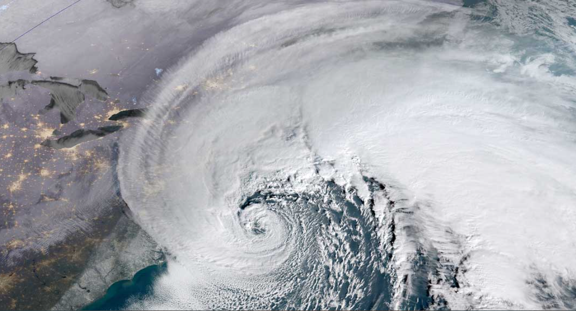
A powerful Nor’Easter bomb cyclone is slamming into Atlantic Canada. The storm brings extreme blizzard conditions and hurricane-force winds. Nova Scotia and Newfoundland face up to three feet of snow.
This explosive weather event marks a severe start to the winter season. It is fueled by a major disruption of the Polar Vortex. The storm will be followed by the coldest air mass Canada has seen since February.
Immediate Impacts: Widespread Blizzard Conditions and Travel Chaos
The storm began its assault Tuesday night. Its intensity peaked throughout Wednesday. Central pressure dropped dramatically, signaling a classic bombogenesis event.
According to Reuters, wind gusts could reach 90 mph. These winds create whiteout conditions. Roads have become impassable across the region.
Local officials report widespread power outages. Emergency services are struggling to respond. Residents are urged to stay indoors and avoid all travel.
The Driving Force: Polar Vortex Collapse and Explosive Development
This extreme weather stems from a collapsing Polar Vortex. The vortex is a large area of low pressure and cold air. Its breakdown allows frigid Arctic air to surge southward.
This cold air is colliding with warm, moist Atlantic air. The clash creates a perfect environment for rapid intensification. The storm’s pressure drop far exceeds the threshold for a bomb cyclone.
Meteorologists from the BBC confirm the pattern. They note such events are becoming more volatile. This storm is a textbook example of modern winter extremes.
What Comes Next: A Prolonged and Dangerous Cold Snap
The storm’s departure does not mean relief. A brutal Arctic air mass is moving in behind it. Temperatures are forecast to plunge 30 degrees below normal.
This cold will grip central and eastern Canada for days. It represents the most significant cold snap in nearly a year. The combination of deep snow and extreme cold is particularly hazardous.
Infrastructure already strained by the blizzard will face new tests. Frozen pipes and heating system failures are major concerns. The public must prepare for an extended period of severe winter weather.
Broader Implications for a Turbulent Winter Season
This bomb cyclone may be a sign of things to come. The unstable Polar Vortex suggests a pattern of frequent cold waves. Weather models show more potential for disruptive storms.
The early season severity is notable. It aligns with broader climate patterns observed in recent years. Scientists are studying these connections intensively.
Preparedness is now more critical than ever. Communities must remain vigilant throughout the winter. Rapidly changing conditions require constant attention to forecasts.
This Nor’Easter bomb cyclone underscores the raw power of winter. Its historic snowfalls and impending deep freeze will challenge Atlantic Canada. The event highlights the increasing frequency of such extreme weather phenomena.
Thought you’d like to know
What is a bomb cyclone?
A bomb cyclone is a storm that intensifies rapidly. Its central pressure drops very quickly over 24 hours. This leads to a powerful and dangerous weather system.
Which areas are most affected by this storm?
Nova Scotia and Newfoundland are experiencing the most severe impacts. These provinces face the heaviest snow and strongest winds. Coastal communities are particularly at risk from blizzard conditions.
How much snow is expected from this Nor’Easter?
Some regions could see accumulations of up to three feet. The highest totals are likely in localized bands. Widespread amounts over one foot are forecast for a large area.
What is causing this extreme winter weather?
A major disruption of the Polar Vortex is the primary cause. This allows Arctic air to spill south into Canada. The collision with warmer, moist air creates the powerful storm.
How long will the severe cold last after the storm?
The dangerous cold is expected to persist for several days. It may be a week or more before temperatures return to seasonal averages. This prolonged freeze will follow the heavy snowfall.
iNews covers the latest and most impactful stories across
entertainment,
business,
sports,
politics, and
technology,
from AI breakthroughs to major global developments. Stay updated with the trends shaping our world. For news tips, editorial feedback, or professional inquiries, please email us at
[email protected].
Get the latest news and Breaking News first by following us on
Google News,
Twitter,
Facebook,
Telegram
, and subscribe to our
YouTube channel.


