A powerful Pacific storm is hammering California this week. Southern California faces a critical High Risk of life-threatening flash flooding. Heavy rain and mountain snow will disrupt travel through Christmas.
The National Weather Service has issued its most severe warning. A level 4 out of 4 High Risk for excessive rainfall is in effect. This signals widespread, dangerous flooding is imminent.
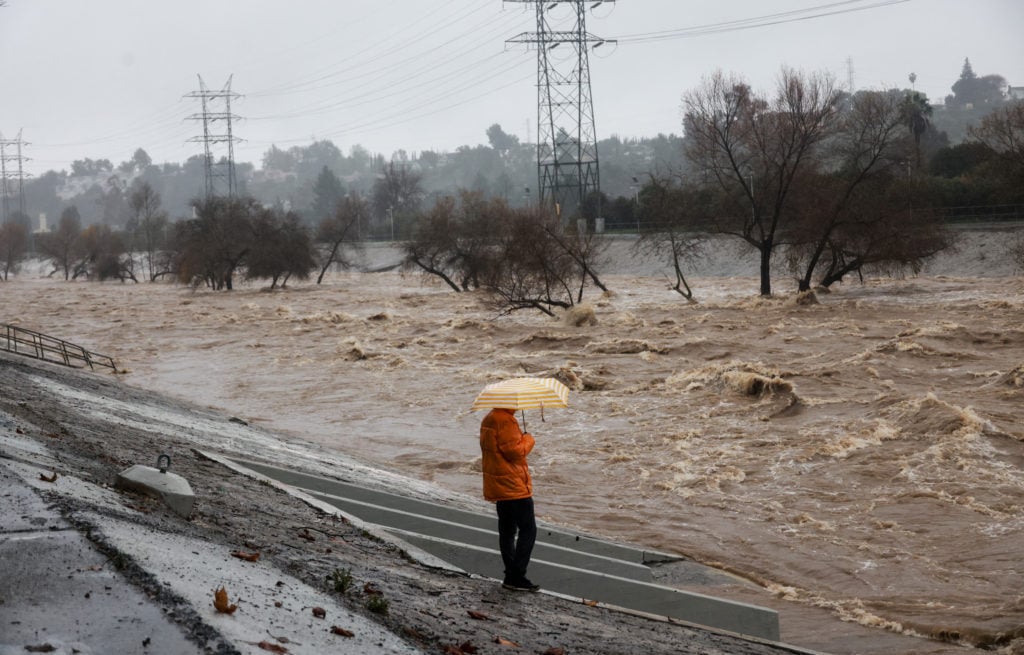
Unprecedented Rainfall Threatens Los Angeles Basin
Rainfall totals will be extreme. Downtown Los Angeles could see 4 to 8 inches of rain. AccuWeather confirms this is two to three times the area’s usual December rainfall.
Short, intense downpours will cause problems. Rates may hit 2 inches per hour. This will quickly overwhelm streets and drainage systems.
The situation is particularly dangerous near recent wildfire burns. Areas scarred by fires are at extreme risk for devastating mudslides. Fast-moving debris flows can destroy homes and roads with little warning.
Major Travel Disruptions Expected Statewide
The storm’s impact extends far beyond flooding. The Sierra Nevada mountains will bear the brunt of heavy snow. Some peaks may receive over 10 feet of fresh snow.
Major travel corridors will be severely affected. Interstate 80 over Donner Pass could see temporary closures. Snow levels may drop to 5,000 feet by Christmas Day.
Air travel will also face significant hurdles. Major hubs like LAX and SFO expect delays and cancellations. Strong winds and low visibility are the primary causes.
This multi-faceted storm presents a severe threat to life and property across California. Residents and travelers must heed all warnings and avoid non-essential travel during the peak of this severe weather event.
Info at your fingertips
What areas are at greatest risk for flooding?
The greatest risk is in Southern California, especially the Los Angeles basin. The National Weather Service has placed this region under a rare High Risk warning. Burn scars from recent wildfires are in extreme danger.
How much snow is expected in the mountains?
AccuWeather forecasts an astounding 8 to 12 feet for Sierra Nevada peaks. Some locations could see up to 15 feet. Lower elevations near 5,000 feet will also see snow by Christmas.
Will this storm affect holiday air travel?
Yes, significant disruptions are likely. Airports in Los Angeles, San Francisco, and Sacramento may experience delays and cancellations. Strong winds and poor visibility are the main factors.
Are power outages expected?
Widespread power outages are possible. Wind gusts of 40 to 60 mph can topple trees and power lines. The strongest gusts may exceed 80 mph in mountainous regions.
When will the storm finally ease?
The most intense rain and snow will continue through Thursday. Conditions will gradually improve from Friday into Saturday. However, lingering moisture will keep travel hazardous through the weekend.
Trusted Sources: National Weather Service Weather Prediction Center, AccuWeather
iNews covers the latest and most impactful stories across
entertainment,
business,
sports,
politics, and
technology,
from AI breakthroughs to major global developments. Stay updated with the trends shaping our world. For news tips, editorial feedback, or professional inquiries, please email us at
[email protected].
Get the latest news and Breaking News first by following us on
Google News,
Twitter,
Facebook,
Telegram
, and subscribe to our
YouTube channel.


