A powerful new winter storm is bearing down on the United States. It threatens to disrupt New Year’s Eve plans across the Midwest and Northeast. The system arrives this Sunday, December 29.It follows a massive post-Christmas snowstorm that caused emergencies in New York and New Jersey. This fast-moving storm will bring a dangerous mix of snow, ice, and Arctic cold.
Blizzard Conditions and Heavy Snow Forecast
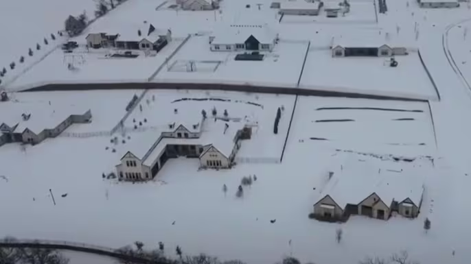
The storm will travel across the Midwest beginning Sunday. It is expected to drop 5 to 8 inches of snow in many areas. Some locations could see significantly more.Parts of the northern Great Lakes and northern New York State may get up to 18 inches. A blizzard warning is now in effect for Minnesota, Wisconsin, and northern Michigan.Winds there could reach 55 mph. This will create whiteout conditions where visibility drops to zero. Total whiteouts are expected just west of Minneapolis, according to weather officials.Winter weather advisories stretch from Wisconsin to New Jersey. Ice and freezing rain will cause problems from Sunday into the night. In cities like Chicago and Cleveland, warm rain on existing snow may cause flash flooding.
Coastal Rain and Widespread Icy Threats
Major I-95 corridor cities will see mostly rain. New York, Philadelphia, and Boston may start with a brief period of ice pellets. This will quickly change to rain as temperatures rise.The situation is more dangerous farther north. Freezing rain and ice are predicted for New England, especially in higher elevations. A glaze of up to a tenth of an inch of ice is possible.Strong wind gusts across the region also raise the risk of power outages. Meanwhile, the storm’s southern edge brings a Level 1 severe weather risk.Areas like Indianapolis, St. Louis, and Nashville face damaging winds. There is also a slight chance of isolated tornadoes forming.
From Flying Fists to Poop Talk: Hollywood’s Most Bizarre Celebrity Confessions
By Monday, the storm will depart but leave behind a brutal blast of Arctic air. This US blizzard warning event will give way to temperatures far below normal for early January.
Thought you’d like to know-
Which areas are under a blizzard warning?
Blizzard warnings are active for parts of Minnesota, Wisconsin, and northern Michigan. These areas face heavy snow and winds over 50 mph, creating dangerous whiteout conditions.
Will New York City get snow from this storm?
New York City is expected to get mostly rain. The city may see a brief period of ice pellets at the storm’s start before changing to all rain.
What is the main travel hazard in the Northeast?
Freezing rain is the primary concern for inland and northern parts of the Northeast. This will create a layer of ice on untreated roads and sidewalks, making travel very hazardous.
Could this storm cause power outages?
Yes. Strong wind gusts accompanying the storm across the Northeast and New England increase the likelihood of power outages, especially where ice accumulates on trees and lines.
How will the weather be for New Year’s Eve?
By late Sunday night, precipitation will end in the East. However, extremely cold Arctic air will rush in, leading to very low temperatures for New Year’s Eve celebrations outdoors.
Trusted Sources: Reuters, National Weather Service
iNews covers the latest and most impactful stories across
entertainment,
business,
sports,
politics, and
technology,
from AI breakthroughs to major global developments. Stay updated with the trends shaping our world. For news tips, editorial feedback, or professional inquiries, please email us at
[email protected].
Get the latest news and Breaking News first by following us on
Google News,
Twitter,
Facebook,
Telegram
, and subscribe to our
YouTube channel.


